Location: Cordillera Administrative Region (CAR)
Total Area Covered: 85082 Ha
Total Forest Land Area: 78041 Ha
Total Alienable & Disposable: 7041 Ha
Total Population: 446224
Province Covered: Benguet, Ifugao, Nueva Vizcaya, Mt. Province
Municipalities Covered: 13
Barangays Covered: 63
Host Communities: Province: Benguet; Municipalities: Bokod, Itogon; Barangay: Tinongdan, Ambuclao, Tikey
Watershed Images
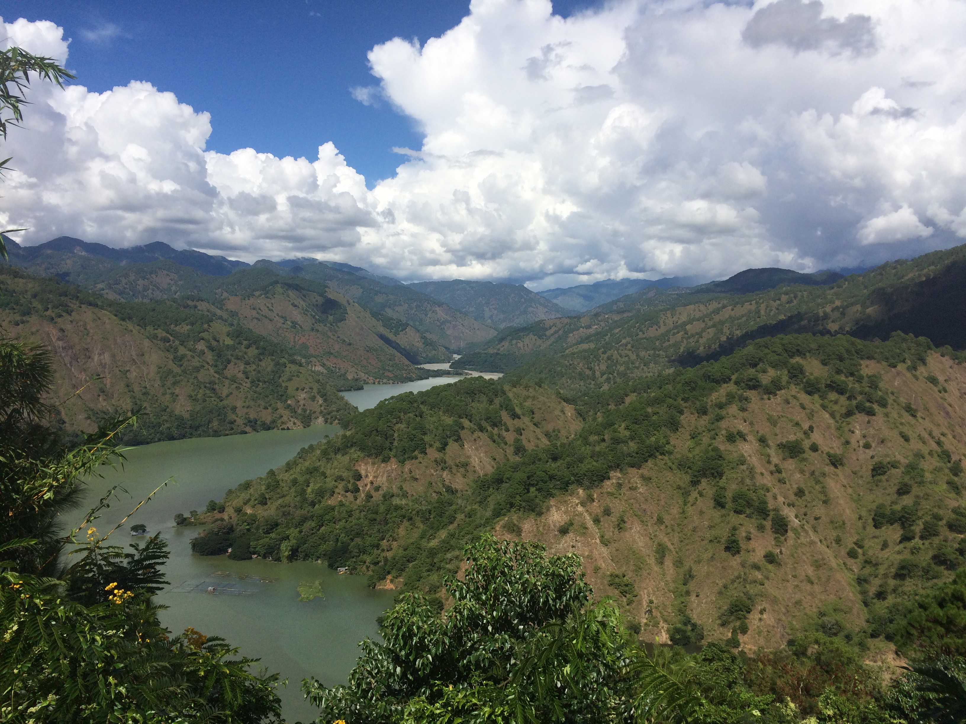
The Ambuklao-Binga Watershed, also known as the Upper Agno Watershed, is the headwater of the Agno River Basin watershed situated in the Cordillera Administrative Region, Northern Luzon. Geographically, it is located between 160 18’ 40.76” to 160 18’ 19.04” latitude and between 1200 54’ 20.82” to 1200 55’ 5.15” longitude. The watershed is within the province of Benguet and some portions of the adjoining provinces of Mountain Province and Nueva Vizcaya. It is bounded on the north by Buguias, Mountain Province, on the south by the municipality of Itogon, Benguet, on the east by municipality of Kayapa, Nueva Vizcaya and on the west by Municipality of Atok, Benguet. ..
Forestland : 78041
Alienable & Disposable (Ha) : 7041
Dominantly the area is classified as Forest lands, 92% of the total watershed area are Forestlands and only 8% were Alienable and Disposable lands. Most of the forestlands are situated in the municipality of Bokod followed by Municipalities of Buguias and Kabayan. Alienable and Disposable lands are mainly found in Kabayan and Bokod. Municipality A&D (Ha) Forestland (Ha) Total(Ha) Atok 290.66 388.37 679.03 Bakun 41.89 337.10 378.99 Bauko 392.92 392.92 Bokod 1,911.37 38,004.27 39,915.64 Buguias 830.97 14,390.26 15,221.23 Hungduan 0.38 734.08 734.45 Itogon 585.75 6,024.19 6,609.94 Kabayan 2,915.32 13,029.32 15,944.64 Kayapa 44.53 1,326.44 1,370.97 La Trinidad 410.34 739.34 1,149.69 Mankayan 40.67 40.67 Tinoc 1,012.84 1,012.84 Tublay 9.83 1,621.65 1,631.47 Grand Total 7,041.03 78,041.45 85,082.48.
|
Municipality |
A&D (Ha) |
Forestland (Ha) |
Total (Ha) |
|---|---|---|---|
|
Atok |
290.66 |
388.37 |
679.03 |
|
Bakun |
41.89 |
337.10 |
378.99 |
|
Bauko |
392.92 |
392.92 |
|
|
Bokod |
1,911.37 |
38,004.27 |
39,915.64 |
|
Buguias |
830.97 |
14,390.26 |
15,221.23 |
|
Hungduan |
0.38 |
734.08 |
734.45 |
|
Itogon |
585.75 |
6,024.19 |
6,609.94 |
|
Kabayan |
2,915.32 |
13,029.32 |
15,944.64 |
|
Kayapa |
44.53 |
1,326.44 |
1,370.97 |
|
La Trinidad |
410.34 |
739.34 |
1,149.69 |
|
Mankayan |
40.67 |
40.67 |
|
|
Tinoc |
1,012.84 |
1,012.84 |
|
|
Tublay |
9.83 |
1,621.65 |
1,631.47 |
|
Grand Total |
7,041.03 |
78,041.45 |
85,082.48 |
Source: NAMRIA Maps
The dominant tenurial instrument within the watershed area is Community-Based Forest Management Agreement (CBFMA), followed by Community Stewardship Contract and Special Land Use Permits while the rest of the watershed is untenured hence the Upper Agno River Basin or Ambuklao-Binga Watershed is characterized as critical watershed and proclaimed as a watershed resource reserve. Aside from the Upper Agno River Basin Resource Reserve (77,682 Ha) found also within the watershed is the Mt Pulag National Park (5,467 Ha).
|
Municipality |
CBFMA |
CSC |
SLUP |
Untenured |
|
Atok |
|
|
|
679.03 |
|
Bakun |
|
|
0.28 |
378.71 |
|
Bauko |
|
|
|
392.92 |
|
Bokod |
988.05 |
|
|
38,927.60 |
|
Buguias |
52.35 |
13.39 |
0.03 |
15,159.57 |
|
Hungduan |
|
|
|
734.45 |
|
Itogon |
232.50 |
|
|
6,377.44 |
|
Kabayan |
|
|
|
15,944.64 |
|
Kayapa |
|
|
|
1,370.97 |
|
La Trinidad |
|
|
|
1,149.69 |
|
Mankayan |
|
|
|
40.67 |
|
Tinoc |
|
|
|
1,012.84 |
|
Tublay |
39.83 |
|
|
1,591.64 |
|
Grand Total |
1,312.72 |
13.39 |
0.31 |
83,760.17 |
Source: NAMRIA MAP
Also within the watershed area, CADT and CAD areas were identified occupied and claimed by different tribes. Majority of the tribes are Kankanaey and densely found in the Municipality of Bokod, Buguias and Kabayan.
|
Municipality |
CADT'S-CAD'S (Ha) |
|
Atok |
679.03 |
|
Bakun |
378.99 |
|
Bauko |
392.91 |
|
Bokod |
37,767.75 |
|
Buguias |
15,094.93 |
|
Hungduan |
734.45 |
|
Itogon |
7,927.73 |
|
Kabayan |
16,385.28 |
|
Kayapa |
882.01 |
|
La Trinidad |
1,149.69 |
|
Mankayan |
40.67 |
|
Tinoc |
1,012.84 |
|
Tublay |
1,631.47 |
|
Grand Total |
84,077.74 |
Source: NAMRIA MAP
TOPOGRAPHY
Highest Elevation (meters) : 2922
Lowest Elevation (meters) : 569
Ambuklao-Binga Watershed is generally a rugged, rolling plains and mountainous terrain. It has an elevation ranging from 882 meters to 2,922 meters above sea level. The highest peak is at Mount Pulag with an elevation of 2,922 meters above sea level located at the eastern part of the watershed. The lowest elevation is at Barangay Tinongnan, Itogon along the Upper Agno River with an elevation of 882 meters. Ambuklao-Binga Watershed has an elevation ranging from 882 masl to 2,922 masl. Based on the elevation map derived from the IFSAR DEM, 98% of the areas in the watershed are situated above 1,000 masl. Areas below 1,000 masl is only about 2% with an area of about 481 hectares. The average elevation of Ambuklao-Binga Watershed area is 1,832 masl. The slope of the watershed is dominantly categorized as very steep and severely steep slope with slope greater than 50%. About forty percent (40%) of the area is severely steep seventeen percent (17%) is characterized as steep, twelve percent (12%) is considered as level to gently sloping and eight percent (8%) is under moderate.
Ambuklao-Binga Watershed falls under Type I of the Corona Climatic Type. Climatic Type 1 is experienced all throughout the watershed areas with distinct wet and dry season. Generally, the watershed has a Mean Annual Rainfall of 1,829.4 mm (highest in December 233.7 mm) with 163 rainy days (26 in July and August) based from climate-data.org and Mean Annual Temperature with 23.730C highest and 15.540C lowest (25.30C maximum in April and 13.30C Lowest in January).
The dominant soil type of Ambuklao-Binga Watershed is undifferentiated mountain soil comprising of 43% of the total land area and Guinaong loam with 15%. Mountain soil type is found in the western most part of Mt. Pulag and Guinaong loam in the northern most past of watershed. The northern part of the watershed is where intensive farming is evident particularly in the Municipality of Buguias.
|
Soil Type |
Area (Ha) |
Percent (%) |
|---|---|---|
|
Ambassador silt loam |
8,472.05 |
9.96% |
|
Annam clay loam |
466.06 |
0.55% |
|
Atok clay loam |
20.44 |
0.02% |
|
Bakakeng clay |
2,491.58 |
2.93% |
|
Burgos clay |
1,507.04 |
1.77% |
|
Daclan clay loam |
8,656.12 |
10.17% |
|
Guimbalaon-Annam complex |
1,773.86 |
2.08% |
|
Guinaong loam |
2,723.99 |
14.95% |
|
Halsema clay loam |
632.64 |
0.74% |
|
Mountain soil (undifferentiated) |
36,712.63 |
43.15% |
|
Natubien loam |
3,870.37 |
4.55% |
|
Puguis gravelly loam |
8.91 |
0.01% |
|
Rough Mountainious land |
6,925.05 |
8.14% |
|
Sabangan |
101.46 |
0.12% |
|
Tacdian clay loam |
135.31 |
0.16% |
|
Umingan sandy loam |
584.96 |
0.69% |
|
Grand Total |
85,082.48 |
Source: NAMRIA MAP
Based on the Geologic Maps of Mines and Geosciences Bueau (MGB), the geologic composition in Ambuklao-Binga Watershed is dominated by Oligocene-Miocene (sedimentary and metamorphic rocks) covering 47% of the total area and Neogene with 31%. Oligocene-Miocene (sedimentary and metamorphic rocks are concentrated in the northern part of the watershed and mostly in the Municipality of Bokod. Neogene are mostly found in the municipality of Itogon in lower portion of the watershed.
|
Geology |
Area (Ha) |
Percentage (%) |
|---|---|---|
|
NEOGENE |
26,876.65 |
31.6% |
|
OLIGOCENE-MIOCENE (SEDIMENTARY & METAMORPHIC ROCKS) |
40,419.95 |
47.5% |
|
PLIOCENE-QUATERNARY |
1,783.82 |
2.1% |
|
UNDIFFERENTIATED |
15,983.89 |
18.8% |
|
UPPER MIOCENE-PLIOCENE |
18.18 |
0.0% |
|
Grand Total |
85,082.48 |
|
About 96% of the watershed area is within the Province of Benguet and largely within the municipality of Bokod (47%), Kabayan (19%) and Buguias (18%). The main outlet of the Ambuklao-Binga Watershed is situated in Brgy. Tinongdan, Itogon which the Binga Hydro Electric Power Plant operated by SN Aboitiz Power Benguet, Inc.
|
Municipalities covered |
Area within Watershed (Ha) |
Percentage (%) |
|---|---|---|
|
Benguet |
81,571.30 |
96% |
|
Atok |
679.03 |
0.8% |
|
Bakun |
378.99 |
0.4% |
|
Bokod |
39,915.64 |
46.9% |
|
Buguias |
15,221.23 |
17.9% |
|
Itogon |
6,609.94 |
7.8% |
|
Kabayan |
15,944.64 |
18.7% |
|
La Trinidad |
1,149.69 |
1.4% |
|
Mankayan |
40.67 |
0.0% |
|
Tublay |
1,631.47 |
1.9% |
|
Ifugao |
1,747.29 |
2.1% |
|
Hungduan |
734.45 |
0.9% |
|
Tinoc |
1,012.84 |
1.2% |
|
Mountain Province |
392.92 |
0.5% |
|
Bauko |
392.92 |
0.5% |
|
Nueva Vizcaya |
1,370.97 |
1.6% |
|
Kayapa |
1,370.97 |
1.6% |
|
Grand Total |
85,082.48 |
|
Source: NAMRIA Maps
Bifurcation Ratio
Rb=Nu/Nu+1
Values 3 to 5 the Watershed has normal drainage which means not prone to flooding
The relationship of the total of stream of any given order to the number of streams in the next order is called bifurcation ratio. The higher the number of streams that converges into one stream, the higher risk of flooding.
Drainage Density
D=TL/A
Ratio of the Total Stream Lenght (TL) and area of the watershed
Circularity Ratio
Rc = A/Ao or 4∏A/P2
Circularity ratio is the ratio of the area of the drainage basin or watershed to the area of a circle having the same perimeter as the watershed.
The lower the value indicates a lower flash flood risk.
1 high risk; below 1 low risk
Elongation Ratio
Basin Length/Area (m) * Pi
The diameter of a circle having the same area as the watershed/ divided by the length of the longest axis of the watershed is called the elongation ratio.
The lower the ratio, the more elongated the watershed basin is, thus the lower the risk to flash flood since the flow of the water is longer time.
0.7 to 0.9 the watershed is oval hence not prone to flooding
Watershed Perimeter
Total length of the watershed boundary
The area of the watershed is one of the most important parameter as it reflects the volume of water that can be generated from rainfall.
The Watershed is dominated by Benguet Pine (Pinus kesiya) which constitute its Pine Forest areas and mossy forest situated in higher elevation particularly in Mt. Pulag. Land Cover and vegetation is composed mainly of Open Forest (39,625 ha), Wooded Grassland (17,560 ha), and Annual Crop (14,871 ha). The Ambuklao-Binga Watershed have declared as a watershed reservation known as " Upper Agno River Basin Resource Reserve" and partly covers the Mt Pulag National Park in which it is under the jurisdiction of National Power Corporation - UARWAT and Protected Area Management Board - DENR.
|
Landcover (AGG 14 -2010) |
Area (Ha) |
Percentage (%) |
|---|---|---|
|
Annual Crop |
14,871.65 |
17.5% |
|
Built-up |
450.65 |
0.5% |
|
Closed Forest |
4,106.23 |
4.8% |
|
Grassland |
5,345.00 |
6.3% |
|
Inland Water |
1,446.47 |
1.7% |
|
Open Forest |
39,625.62 |
46.6% |
|
Open/Barren |
288.80 |
0.3% |
|
Shrubs |
1,387.16 |
1.6% |
|
Wooded grassland |
17,560.90 |
20.6% |
|
Grand Total |
85,082.48 |
SNAP Benguet, Inc. contributes to the reforestation activities within the watershed in which 109,344 seedlings of various fruit trees, coffee and forest trees under the APARKs, MCD Reforestation, and annual tree planting activities from 2008-2017.
In Benguet area, there are presence and sightings of Northern Luzon Giant Cloud Rat (Phloeomys pallidus) and Philippine Serpent Eagle (Spilornis holospilus).
(coming soon....)
Forest Cover : 74% forest cover
Poverty Incidence :2
Population Density :2 per hectare
Soil Erosion :1 USLE units
(coming soon...)
Number of household - 106838
Household Population - 444634
Total Population - 446224
CAR as of 2015 census has a total population of 1.72 million (NSO). Benguet which covers the most areas in the Ambuklao-Binga Watershed, as of 2015 has a total population of 446,224 (NSO 2015). Itogon has 59,820 population which ranked 3rd and Brgy Ampucao and Virac is consider one of the 10 most populous areas in CAR.
Source: https://www.psa.gov.ph/content/population-cordillera-administrative-region-based-2015-census-population
Benguet has a sex ratio of 107.89 form the 214,643 female population and 231,591 male population.
Poverty Threshold in Cordillera Administrative Region (CAR)
|
Municipality |
2000 |
2003 |
2006 |
|
Abra |
P13,426 |
P14,654 |
P17,900 |
|
Apayao |
11,368 |
12,256 |
17,837 |
|
Benguet |
14,014 |
14,447 |
17,483 |
|
Ifugao |
11,809 |
13,148 |
15,556 |
|
Kalinga |
11,652 |
13,284 |
15,031 |
|
Mountain Province |
15,122 |
14,855 |
16,785 |
|
CAR |
13,071 |
12,309 |
16,810 |
|
Philippines |
11,458 |
12,309 |
15,057 |
Large portion of the Cordillera Administrative Region is claimed by the Indigenous Peoples, the whole CAR is considered as an IP Domain areas dominated by tribes such as Kankana-ey, Ibaloi and Kalanguya
|
Tribe |
Population |
|
Bago & Kankana-ey |
17,218 |
|
Ibaloy, Kalanguya & Kankana-ey |
733,894 |
|
Kalanguya |
72,798 |
|
Kalanguya & Kankanaey |
994,280 |
|
Kankana-ey |
122,360 |
|
Kankana-ey & Ibaloi |
88,520 |
|
Kankana-ey, Ibaloi & Kalanguya |
107,368 |
|
Kankana-ey, Ibaloi, Kalanguya & Karao |
568,376 |
|
Kankana-ey/Ibaloi |
217,832 |
|
Kankan-ey & Ibaloy |
250,144 |
|
Grand Total |
3,172,790 |
|
Municipality/Tribe |
Area (Ha) |
|
Atok |
679.03 |
|
Kankan-ey & Ibaloy |
679.03 |
|
Bakun |
378.99 |
|
Bago & Kankana-ey |
0.21 |
|
Kalanguya & Kankanaey |
346.22 |
|
Kankana-ey |
32.56 |
|
Bauko |
392.91 |
|
Kalanguya |
2.34 |
|
Kalanguya & Kankanaey |
164.62 |
|
Kankana-ey |
225.95 |
|
Bokod |
37,767.75 |
|
Ibaloy, Kalanguya & Kankana-ey |
968.77 |
|
Kankana-ey & Ibaloi |
365.61 |
|
Kankana-ey, Ibaloi, Kalanguya & Karao |
34,486.31 |
|
Kankana-ey/Ibaloi |
10.65 |
|
Kankan-ey & Ibaloy |
1,936.41 |
|
Buguias |
15,094.93 |
|
Ibaloy, Kalanguya & Kankana-ey |
370.76 |
|
Kalanguya |
249.82 |
|
Kalanguya & Kankanaey |
14,463.79 |
|
Kankana-ey |
10.56 |
|
Hungduan |
734.45 |
|
Kalanguya |
97.59 |
|
Kalanguya & Kankanaey |
636.86 |
|
Itogon |
7,927.73 |
|
Kankana-ey & Ibaloi |
781.06 |
|
Kankana-ey, Ibaloi & Kalanguya |
366.09 |
|
Kankana-ey, Ibaloi, Kalanguya & Karao |
3,026.40 |
|
Kankana-ey/Ibaloi |
3,754.18 |
|
Kabayan |
16,385.28 |
|
Ibaloy, Kalanguya & Kankana-ey |
15,309.87 |
|
Kalanguya & Kankanaey |
83.29 |
|
Kankana-ey, Ibaloi, Kalanguya & Karao |
601.25 |
|
Kankan-ey & Ibaloy |
390.88 |
|
Kayapa |
882.01 |
|
Ibaloy, Kalanguya & Kankana-ey |
121.12 |
|
Kankana-ey, Ibaloi, Kalanguya & Karao |
760.89 |
|
La Trinidad |
1,149.69 |
|
Kankana-ey & Ibaloi |
439.36 |
|
Kankana-ey, Ibaloi & Kalanguya |
710.33 |
|
Mankayan |
40.67 |
|
Kalanguya & Kankanaey |
40.67 |
|
Tinoc |
1,012.84 |
|
Ibaloy, Kalanguya & Kankana-ey |
443.08 |
|
Kalanguya |
352.89 |
|
Kalanguya & Kankanaey |
216.87 |
|
Tublay |
1,631.47 |
|
Kankana-ey & Ibaloi |
1,628.43 |
|
Kankan-ey & Ibaloy |
3.04 |
|
Grand Total |
84,077.74 |
Most (43 percent) of the household population in Benguet classified themselves as Kankanai/Kankaney/Kankanaey. About 29.2 percent considered themselves as Ibaloi and 13.4 percent as Ilocano. Other ethnic groups included Ikalahan (3.7 percent) and Tagalog (2.4 percent).
Internal Revenue Allotment (IRA) as of 2012 is 517.9 million Php (NSCB) Annual per Capita Food Threshold Annual Per Capita Food Threshold – 11,019 Php as of 2009 Annual per Capita Poverty Threshold Annual per Capita Poverty Threshold – 15,820 Php as of 2009
IRA (million pesos) of 540.4, rank 61, Percentage of IRA to total Financial Resources 53.6, Rank 68 (2011)
Ambuklao-Binga Watershed List of Stakeholder Groups
Fishcage Operators/Owners and Fisherfolks
Tinongdan Indigenous Peoples Organization (TINPO)
Shakilan ni Ikulos Indigenous Peoples Organization (SNIPO)
National Power Corporation - Upper Agno Riverbasin Watershed Team (NPC-UARWAT)
Local Government Units (LGUs)
Ambuclao Coffee Growers Association, Inc (ACGA)
SN Aboitiz Power-Benguet, Inc. (Binga HEPP and Ambuklao HEPP)